
Which drone will spot a heat signature through smoke before it becomes a catastrophe? Thermal imaging has jumped from lab racks to portable drones, and that shift is changing how professionals work. Advances in sensors, onboard processing, and flight autonomy now deliver clearer heat maps and smarter, safer flights.
This guide rounds up the five best thermal-imaging drones for 2026. We evaluated them across real-world tasks, including imaging clarity, flight endurance, obstacle handling, and ruggedness, testing in smoke, fog, low light, and dense foliage to mirror field conditions. Our goal was to identify platforms that perform reliably in tough environments, not just on paper, and to cut through marketing claims.
The audience for these systems is broad. Emergency responders, search-and-rescue units, utility and infrastructure inspectors, farmers, security teams, and environmental researchers all gain practical advantages from thermal aerial data. Whether you need rapid hotspot location, night-time search missions, routine thermal surveys of assets, or wildlife monitoring, the right drone reshapes the mission.
You’ll get clear, mission-focused buying guidance that matches capabilities to priorities and budgets. Expect concise profiles, real-world use notes, and pragmatic advice on deployment, maintenance, and data handling. No spec overload—just actionable recommendations so you can choose the best drone for thermal imaging that fits your mission.

Autel EVO Max 4T V2 with visible/zoom/thermal/laser quad-sensor, 48MP 1/2
1. DJI Mavic 3T Highlights

DJI Mavic 4 Pro with DJI RC 2, Hasselblad 100MP 4/3 CMOS tri-camera
Professional aerial imaging with 100MP four-thirds sensor, tri-camera versatility, intelligent flight modes and cinematic stabilization for unmatched high-resolution photography.
Check PriceThe Mavic 3T is a surprisingly compact thermal platform that feels at home on both a fireground and an inspection job. Its 640×512 thermal sensor (12 µm, 30 fps) delivers excellent clarity and can reveal heat through smoke, fog, and dense foliage — critical when you need answers fast.
Pair that thermal sensor with a 48MP wide-angle RGB camera and a 56× hybrid zoom, and you’ve got context plus detail in a single package. I often use the RGB for framing and the zoom to read small targets on pylons or roofs without getting dangerously close.
Battery life is a big advantage: up to 45 minutes of flight time lets you sweep larger areas or handle lengthier inspections without constant landings. That endurance, combined with omnidirectional obstacle avoidance, makes it a reliable tool in cluttered, night-time, or hard-to-access environments.
Field feedback lines up with what I expect: firefighters love it for hotspot location and situational awareness, and inspectors rely on its thermal clarity for night and infrastructure checks. The foldable, portable design also means quick deployment when minutes matter.
There are trade-offs. This drone is clearly aimed at professional and enterprise users rather than casual hobbyists, and the mighty 56× hybrid zoom can sometimes introduce digital noise in certain conditions. Still, for emergency responders, utility teams, and industrial maintenance pros, the Mavic 3T is a versatile, high‑performing option that balances image quality, flight time, and portability.
- Exceptional thermal image quality and resolution
- Up to 45 minutes flight time
- Omnidirectional obstacle avoidance
- Compact and quick to deploy
- Geared toward professional/enterprise users
- Extreme zoom can introduce digital noise
2. Autel Robotics EVO Max 4T XE Highlights
Autel EVO Max 4T V2 with visible/zoom/thermal/laser quad-sensor, 48MP 1/2
Versatile quad-sensor platform combining visible, zoom, thermal and laser for inspection, mapping and long-range surveillance with 48MP 8K imaging and high-res thermal.
Check PriceAs a photographer who often works with thermal inspections, I appreciate the Autel Robotics EVO Max 4T XE for its balanced mix of imaging power and robust navigation. The 640×512 thermal sensor paired with a 50MP optical camera gives you crisp thermal maps plus high-detail visual context for reports and clients.
Where this drone really shines is in cluttered or GPS‑denied environments. Its “720°” obstacle avoidance—driven by binocular vision sensors and millimeter‑wave radar—creates confidence flying close to structures or through dense foliage.
SLAM navigation lets you operate where GPS fails, and Autel’s A‑Mesh connectivity delivers reliable reception across longer missions. With roughly 42 minutes of flight time you can complete comprehensive grid or orbital surveys without constant battery swaps.
Users note the EVO Max 4T XE’s strong imaging and mapping capabilities: thermal plus optical zoom is excellent for pinpointing faults, hot spots, or small details on infrastructure. Radio control feels responsive and handling is intuitive, which matters when you’re framing both thermal and RGB shots.
The tradeoffs are practical: the controller is heavy and can tire operators during long shifts, and the mission‑planning software is powerful but carries a learning curve (and may require a subscription for full features). If you need advanced navigation, dependable obstacle avoidance, and professional imaging for inspections or search‑and‑rescue, this platform is mostly a great fit.
- 640×512 thermal + 50MP RGB
- “720°” avoidance with mm‑wave radar
- SLAM for GPS‑denied flight
- ~42 minutes flight time, A‑Mesh reception
- Heavy controller causes fatigue
- Mapping/mission tools need training/subscription
3. DJI Matrice 30T (M30T) Highlights

Antenna for DJI RC Plus (fits Matrice 30T/T40/T20P/M30/M300)
High-performance remote-control antenna enhancing signal range and reliability, designed to fit multiple enterprise drone controllers for uninterrupted long-distance operations.
Check PriceThe Matrice 30T (M30T) is a rugged, enterprise-focused drone built around a multi-sensor payload that includes a 640×512 thermal sensor with a super-resolution mode up to 1280×1024. As a photographer who often needs clean thermal context alongside visual detail, I appreciate that the M30T pairs thermal with integrated zoom and wide-angle sensors for situational awareness.
Flight endurance sits around ~41 minutes, which is long enough for extended inspection passes or search patterns without constant battery swaps. The platform’s omnidirectional obstacle avoidance and advanced AI target tracking keep the aircraft and subjects stable during detailed imaging runs.
Where the M30T really shines is in harsh conditions. It carries an IP55 rating, so you can operate in rain and adverse weather that would ground many consumer models. The super-resolution thermal mode noticeably sharpens heat signatures, improving detection precision for hotspot finding and close inspection tasks.
For measurement and targeting, the integrated laser rangefinder reaches out to 7 km, giving precise distance data during inspections or search operations. That long-range capability combined with AI-assisted tracking is a practical advantage when you’re mapping infrastructure or following moving subjects in complex scenes.
There are trade-offs: the M30T is larger and heavier, so it’s less convenient to carry for quick deployments. It’s also an enterprise tool with higher operational complexity that can require specialized training to fully exploit its features.
- IP55 weather protection
- Super-resolution thermal to 1280×1024
- 7 km laser rangefinder
- Strong AI and omnidirectional avoidance
- Larger and less portable
- Higher operational complexity; needs training
4. Skydio X10 (Thermal) Highlights
Specialized drone accessory or upgrade offering rugged construction, expanded compatibility and improved field performance; contact seller for exact specifications and fitment.
Check PriceThe Skydio X10 (Thermal) is a workhorse for operators who need autonomy without sacrificing image context. Its FLIR Boson+ thermal sensor at 640×512 gives a clear heat-map while the modular payload option lets you add a high‑res RGB camera for visual confirmation. That combination makes it practical for search‑and‑rescue, security sweeps, and infrastructure inspections where identifying a hot spot and then capturing a detailed visual is critical.
What really sets the X10 apart is the AI autonomy and true 360° obstacle avoidance. In cluttered or GPS‑denied environments the drone can fly near‑fully autonomous, letting you focus on mission objectives instead of constant manual piloting. That autonomy reduces pilot workload during long or complex sorties.
For field durability the X10 is IP55 rated and includes built‑in strobe lighting for night ops. Rugged construction and night capability mean it holds up in rough weather and low‑light SAR scenarios. Flight endurance sits around ~40 minutes, which is long enough for extended search patterns or multi‑point inspections.
There are tradeoffs to consider. The autonomy system has a learning curve to unlock its full potential, so new pilots should plan training time. Also, while the arms fold for some portability, the platform is bulkier than light consumer foldables and is geared toward professional use.
- 640×512 FLIR Boson+ thermal sensor
- Advanced AI autonomy with 360° obstacle avoidance
- IP55 weather resistance and built‑in strobe for night ops
- Modular payloads + ~40 minutes flight time
- Steeper learning curve to master autonomy
- Bulkier than consumer foldable drones
5. Autel EVO II Dual 640T V3 Highlights
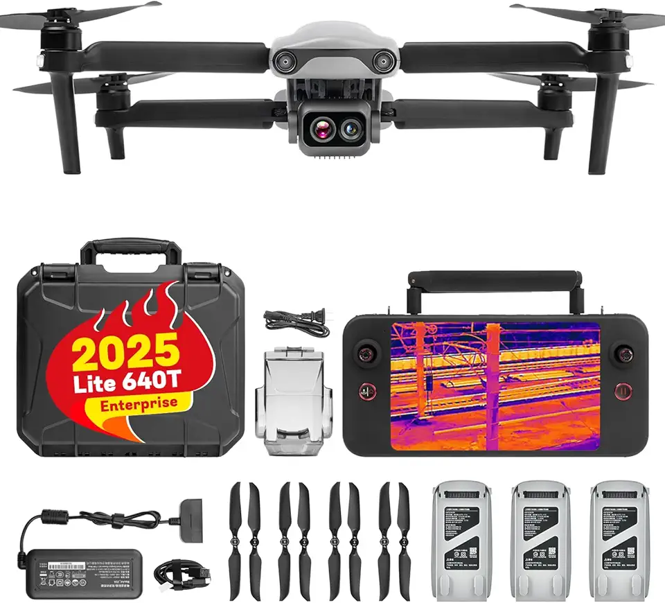
Autel EVO Lite 640T Enterprise, 640×512 30Hz thermal, 48MP 1/2
Enterprise-grade drone payload combining high-sensitivity 640x512 thermal at 30Hz with 48MP visual sensor for precise inspections and rapid situational awareness.
Check PriceAs a working photographer who uses drones for inspections and documentation, the Autel EVO II Dual 640T V3 stands out for combining a true thermal sensor with very high‑resolution visual imaging. It carries a 640×512 thermal sensor at 25 Hz alongside a 50MP RGB camera, which means you get clear heat-signature data plus detailed contextual photos for reports and close-up visual analysis.
The platform is designed around balanced professional use: roughly 38 minutes of flight time gives you solid on-scene coverage, and 360° obstacle avoidance helps maintain safe flights in complex environments. Users report reliable thermal imagery and very high‑res visual photos, so it’s excellent when you need both detection and visual documentation in one sortie.
In practice I find it well suited to infrastructure, agricultural, and firefighting inspections where you often need to pair thermal findings with crisp photographic evidence. There is, however, an initial software/interface learning curve that some operators mention, so expect a short period of familiarization before you’re fully efficient.
If your missions prioritize balanced thermal capability with top-tier RGB detail and dependable obstacle avoidance, this EVO II Dual V3 is a strong, practical choice. If you need the absolute longest flight times or prefer a plug-and-play interface without any learning, those are the only modest compromises to weigh against its imaging strengths.
- 50MP RGB for detailed visual documentation
- 640×512 thermal @ 25 Hz for solid heat detection
- 360° obstacle avoidance for safer flights
- Good balance of thermal + optical inspection capability
- Flight time ~38 minutes is shorter than some rivals
- Initial software/interface learning curve
Common Applications of Thermal Imaging Drones
Thermal imaging drones are surprisingly versatile — they don’t just “see heat,” they tell stories you can’t capture with visible light alone. For firefighters and disaster teams, thermal feeds reveal hot spots through smoke and darkness, helping map fire spread and find survivors. In those scenarios I fly deliberately slow, capturing wide-area sweeps first, then tighten in for high-resolution passes once a hotspot is located.
For infrastructure and industrial inspections the real value is contrast. Overheated electrical gear, failing joints on pipelines, and hot spots on solar arrays stand out clearly in thermal. I always shoot paired RGB frames for context: a thermal hotspot on its own is useful, but a matching visual shot makes reports and repairs far easier to act on.
On farms and in precision agriculture, thermal helps monitor plant stress and irrigation issues over large fields. Early morning flights give the best thermal contrast, so I schedule missions at dawn when soil and canopy temperatures reveal hidden patterns. For livestock, thermal is unbeatable at night — just keep altitude and noise in mind to avoid disturbing animals.
Security and perimeter patrols benefit from continuous thermal sweeps. Night-time intruder detection is a classic use, but successful ops hinge on good patrol routes and overlaying thermal with timestamps and GPS to create actionable alerts. Keep your thermal palette and sensitivity tuned so small human-sized signatures are easy to spot against background clutter.
Environmental and wildlife monitoring is another sweet spot. Heat signatures pierce dense vegetation and darkness, letting you survey populations without intrusive lighting. I recommend using wider orbits and higher altitudes for surveys, then descending for detailed imagery only when you’ve positively identified a target.
No matter the application, think like a visual storyteller: pair thermal and RGB, plan your flight timing for thermal contrast, and use steady, methodical passes. Those simple habits turn raw heat maps into clear, usable information for responders, inspectors, farmers, and conservationists alike.
Operational Tips for Flying Thermal Imaging Drones
When I head out on a thermal mission I treat it like any other shoot: preparation wins. Fully charge batteries, controller and spare batteries, and make sure your microSD cards are formatted and fast enough for high-frame-rate captures. Gently clean the thermal lens with a microfiber cloth and avoid touching it; thermal sensors are sensitive and a smudge can ruin contrast. Power the drone up early so the sensor can reach thermal equilibrium before you start recording.
Timing matters more than many expect. I prefer early morning or late evening when ground-to-air temperature differentials are strongest. Midday sun flattens thermal contrast and creates hot spots that mask real issues. Also avoid high wind, rain, or extreme cold—these reduce stability and can shift the sensor offset.
Fly deliberately. Slow, steady passes or a tight orbit give crisper thermal frames than fast, jerky movements. For inspections I use grid or overlapping passes to ensure full coverage and consistent viewing angles. Capture high-resolution RGB alongside thermal imagery whenever possible; the visual context makes interpretation and reporting far easier.
Mind the physics. Maintain a consistent altitude and distance so your target fills the sensor enough to resolve detail. If you need exact temperatures, bring a calibrated reference target on scene and verify emissivity settings in your software—assumed emissivity can lead to misleading values.
Keep safety and compliance at the forefront. Run through preflight checklists, verify firmware and NOTAMs, and set conservative return‑to‑home and obstacle-avoidance settings. If you’re operating near infrastructure or people, coordinate with site managers and have a clear emergency plan.
Finally, handle your data like a pro. Record metadata, use multiple thermal palettes to reveal different patterns, and overlay RGB for reports. Regularly calibrate and service sensors; small maintenance habits pay off with cleaner, more actionable thermal results in the field.
What People Ask Most
What is the best drone for thermal imaging?
It depends on your mission priorities and operating environment, with different models optimized for portability, autonomy, GPS‑denied flight, or rugged enterprise use. Choose a platform that matches your typical use case and operational needs.
Which drones come with built-in thermal cameras?
Several professional models include integrated thermal sensors, such as the ones reviewed in this guide. Integrated systems simplify deployment for inspections and public‑safety missions.
Can you attach a thermal camera to any drone?
Not necessarily; some drones support modular payloads while others use fixed integrated sensor packages. Always verify manufacturer compatibility and payload support before planning a retrofit.
How accurate is thermal imaging from a drone?
Accuracy varies with sensor quality, calibration, imaging modes, and environmental conditions. For reliable results, focus on thermal patterns and maintain regular calibration and good operating practices.
What thermal sensor resolution do I need for drone inspections?
Many professional systems use common resolutions like 640×512, and some platforms offer super‑resolution modes for greater detail. The right resolution depends on inspection distance, target size, and the level of detail required for your mission.
What are the regulations for flying drones with thermal cameras?
Follow local flight rules, airspace restrictions, and any certification or authorization requirements that apply to your operations. Conduct pre‑flight checks and maintain compliance with privacy and safety regulations.
What is the detection range of drone thermal cameras?
Detection range is not universally specified and depends on sensor optics, resolution, atmospheric conditions, and target characteristics. Range‑related tools like laser rangefinders are separate systems and do not directly define thermal sensor performance.
Conclusion for Best Drone for Thermal Imaging
Choosing the right thermal drone is about matching platform strengths to the mission: prioritize portability and long flight time for rapid deployments, advanced obstacle avoidance or GPS‑denied navigation for cluttered environments, rugged weatherproofing and long‑range sensors for heavy‑duty work, or autonomy and balanced thermal+RGB imaging for complex inspections.
Whatever you fly, reliable results come from disciplined prep — thorough pre‑flight checks, regular thermal sensor calibration, smart timing for thermal contrast, and strict adherence to local regulations and safety protocols.
If you’d like to sharpen your skills and planning for thermal missions, read more on our site to stay current with techniques, workflows, and real‑world tips that improve outcomes.
Have a question or want to share field experience? Leave a comment below and we’ll usually reply within a few hours.




0 Comments